There is so much to see and write about in the United Kingdom! So I will now mention a bit more about North Devon, where some of our family, comprising parents, an elder brother and I had what I would call our first real holiday together. Dad had been involved with the scouts for many years, so the plan was to have a camping holiday. Dad found that there was a campsite at Steart Farm in North Devon, so in our 1937 Ford Eight we drove down there. I was probably about six years old. It took many hours to get from Peterborough to Steart Farm and on our first visit we found that you turned off the main A39 road and went down a fairly steep hill to the farmhouse and yard. Parts of the yard were a bit muddy in places but we saw it was quite easy to get through and up the other side to the where the caravans and tents were. The site consisted of two large fields, an upper and a lower, with all of the camping in the lower field and the caravans in the upper one. Except there had been heavy rain for a few days prior to our visit and the lower field was flooded, so camping was impossible. But the farmer had a few caravans in the upper field for folk to use and previous visitors had given up and gone home, so we used a caravan! We went back there a few times for holidays, including the time I happened to catch mumps and had to be kept isolated, much like the recent Covid-19. Then we found a place called Westward Ho! in our journeys round the area and saw a holiday camp with both caravans as well as small chalets with corrugated iron roofs that meant you could hear the birds walking across them in the early hours of the morning. During my recent research for this blog I came across the South West Coast Path Association and have included some information of a national trail walk which begins and ends at Steart Farm, near Bucks Mills and is around 3.9 miles (6.2 km) in length. It features woodland paths, wildflower meadows and glimpses of stunning sea views through a screen of ancient hanging oaks. The route visits the thatched thirteenth-century Hoops Inn, but you can take the short-cut to the Coast Path for a quicker stroll. To get to the start, buses do run regularly if required between Barnstaple and Kilkhampton, passing Steart Farm.
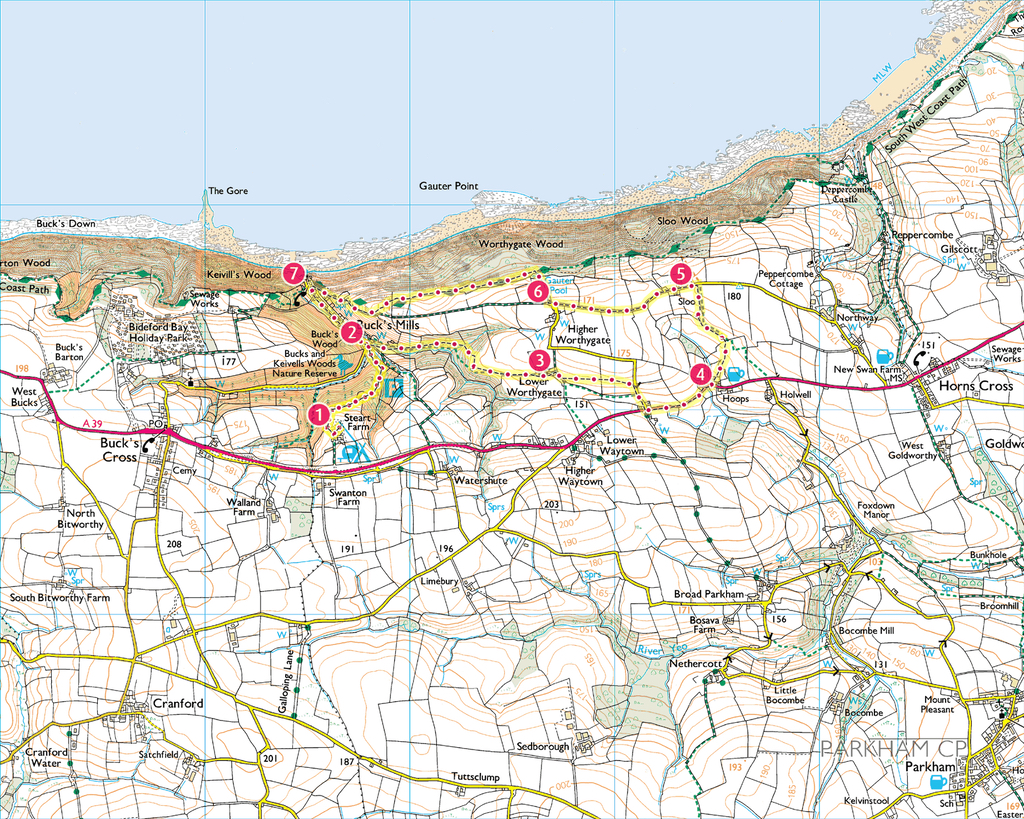
I never did this walk, but as a child I would regularly walk (with my parents of course!) along the main road from the farm to Bucks Cross and the shop, which also had a post office and a telephone box. As you can see from the map, it seems interesting as to begin with, you walk down through the campsite to pick up the signed footpath, going down the steps into the lower terrace of the Middle Burrows camping field. In the woods you then turn left at the waymarker, bearing right shortly afterwards when another path joins from the left. You follow the red waymarkers above the stream, to come out in Bucks Mills Woodland car park. Steart, Walland and Loggins Woods were purchased by the Woodland Trust in 1996, with help from the Heritage Lottery Fund. The woods are mostly broadleaved trees, including oak and beech, with some conifers which were planted more recently, mainly larch and sitka spruce. Over time the Trust aims to reduce the number of conifers and return the woodland to broadleaved species, both naturally and through a programme of planting. There are a number of tracks and paths through the woods, created to carry out forestry operations and the public are welcome to walk along them. Most of the houses in Bucks Mills were built at the beginning of the nineteenth century to accommodate workers on the Walland Cary estate, the manor to the west side of the village. The stream carries on down through the village and once powered the corn mill which gave the village its name. Going out onto the road you turn right, crossing the footbridge, to pick up the narrow footpath to the left of the house ahead. Behind the house the path turns to the right, climbing steadily through the wood and emerging in a meadow. You then follow the right-hand hedge and cross the stile at the far end, beside the barn, carrying on between the buildings at Lower Worthygate Farm to the farm drive. An area of woodland to the left of the path was given over to the Bodgers and Badgers woodland project in October 2000. The project is funded by the National Lottery through its Millennium Commission and the objective is to manage the woodland in line with the conservation strategies used in the neighbouring areas. Traditional skills and techniques are employed, such as coppicing, charcoal-burning and hurdle-making. Volunteers help restore neglected areas through tasks like cutting back hazel stools and erecting deer fencing. The aim is to develop the area as a woodland amenity as well as to encourage wildlife. Guided walks are provided, also flora and fauna surveys are carried out. It was first documented in 1600 that the area was wooded and since that time its oak trees have been used for producing tannin from the bark, charcoal for smelting and making gunpowder, timber for pit-props and shipbuilding (which is done at nearby Appledore) and more recently, for building and firewood. The practice of coppicing – cutting back new growth for commercial use while leaving the main stem to continue growing – means that a tree may live for several centuries. Some of the wildflowers here are only seen in ancient woodland, so look out for the delicate white flowers of wood sorrel, and the clusters of dainty yellow-green leaves of the opposite-leaved golden saxifrage. Watch out, too, for shy roe deer between the trees. For the short route, you turn left up the drive, turning left on the road beyond to join the main route at the footpath at 6 on the above map. To visit the Hoops Inn, on the longer route turn right on the drive to pick up the waymarked footpath leading from the bottom corner of the farm’s garden. The path follows the left-hand boundary of two fields to the road beyond. Turn right and drop down to the main road, turning left here to walk with care along the main road to the Hoops Inn. The A39 along the North Devon coast to Cornwall was named the Atlantic Highway in the 1990s as the name reflects the coastline’s strong ties with the Southern Railway’s ‘Atlantic Coast Express’, which ran daily from London Waterloo between 1926 and 1964. The road itself, travelling between Bideford and Bude, was built long before the arrival of motor vehicles and was the main coaching route into Cornwall from North Devon. The Hoops Inn was one of three coaching inns en route where horses were changed, the other two being the West Country Inn on Bursdon Moor, near Hartland, and in Kilkhampton. It would take all day to travel from Bideford into Bude, and the horses would be returned to the inns on the journey back. The Hoops Inn is a Grade II listed building for its many seventeenth century features, but the original building dates back to the thirteenth century. In Tudor times it was a popular meeting place for seafarers such as Sir Francis Drake, Sir Walter Raleigh and Sir Richard Grenville. It was also known as a notorious smugglers’ haunt. Incidentally, a short distance further on from Hoops Inn is Horns Cross, with a small public house called the Coach and Horses, along with just a few houses. Opposite the pub is what used to be a garage but which is now just a repair centre for certain types of vehicle. In my young days it was a proper garage and petrol station and my dad had his car urgently repaired there, we also became friends with the owners of the place. But back to Hoops Inn. You can head through the archway to the car park, continue straight ahead uphill to go through the gateway at the top into the small field beyond. Then bear left in the field to cross the stile in the far left-hand corner, turning left on the footpath beyond to follow the left-hand hedge of the big field uphill to the road. Turning left on the road, walk past a little place called Sloo and then down to the sharp left-hand bend about half a mile beyond. You take the footpath on the outside of the bend and follow the green lane towards the coast, where it meets the South West Coast Path. Turn left and follow the Coast Path down into Bucks Mills village, coming out on the road a little way up from the beach. The oak woods along this part of the Coast Path are also very old. The remoteness of the location and the steep hillsides mean that they have survived the extensive felling which destroyed the greater part of the ancient forests that once covered the whole of Britain and like the rest of the area’s woodland, it supports a wide diversity of species with a large range of habitats being provided by the scrub, grassland and marsh elsewhere in the valley. As a result, the area is a Site of Special Scientific Interest and is particularly known for its rare lichens. The abundance of wildflowers, such as early purple orchid and marsh orchid, in turn attract butterflies. Here you can look out for the speckled orange-brown, pearl-bordered fritillary, and the well-camouflaged brown dingy skipper. Then turn left on the road and walk back to the woodland car park. Going into the car park, you can take the footpath in the far left-hand corner ahead of you, and follow it back up through the woods to Steart Farm. In my young days I never walked this path, but we often visited nearby Clovelly in order to get there one could either use the ‘main’ road or travel along, as I managed to persuade Dad to do once, the ‘Hobby Drive’. This was built between 1811 and 1829 by Sir James Hamlyn Williams, providing employment for Clovelly men after the Napoleonic wars. It was part of the Romantic movement, which celebrated the beauty of the natural world in response to the increasing emphasis placed on science and logic following the Industrial Revolution. In 1901 Frederick and Christine Hamlyn extended the drive by a further half a mile, making a three-mile carriage drive with breathtaking vistas high above the Atlantic. Over the years the estate has planted new trees in several areas along the drive as part of its woodland management plan, which aims to replace native deciduous trees as they die off, and in the last ten years some 2,500 saplings have been planted each year. In summer pheasant chicks are much in evidence on the lower slopes of the woodland, and pheasant shoots take place between November and January. Nearing the end of the drive you can either turn right to visit Clovelly village, or continue ahead to go straight to the visitor centre, where there is a cafe and a souvenir shop.
For four hundred years, from the fourteenth century to the eighteenth, the village of Clovelly belonged to the Carey family. Then in 1738 it was sold to Zachary Hamlyn, whose descendants have managed it ever since. Built into a cleft in a 400-foot cliff, the whitewashed cottages line a cobbled street which plunges straight down the hillside to the ancient working port below. Using traditional materials and craftsmanship, the family keeps the village in the style of the mid-nineteenth century, and donkeys are used to carry goods uphill, whilst sledges bring things down. From Elizabethan times Clovelly’s main livelihood was from fishing, mostly mackerel and herring, and this provided a prosperous living until the 1840s, when the shoals began to move away. Clovelly herrings were famous throughout the land and donkeys brought the catch uphill to be taken by train to London and the Home Counties. A good day’s catch sometimes amounted to as many as 9,000 herrings, and on one particularly good day 400 donkey-loads were brought in! Even now, fishing is still part of village life, and it is celebrated every autumn in the Herring Festival. The quay was first built in the thirteenth century and extended in Tudor times, then in 1826 the quay was lengthened. The four cannon barrels in use today as bollards are said to have come from the Spanish Armada. Clovelly is the only safe harbour between Appledore and Boscastle, and ships will sometimes wait in Clovelly Roads for storms to pass. Also, because of the number of ships that have been wrecked here, this part of the coast is known as the Iron Coast. This is as a result of the westerly winds rolling in over 3,000 miles of Atlantic Ocean, and the deadly fingers of rock lurking beneath the waves. As a result, Clovelly has had its own lifeboat since 1870. Beyond the lifeboat station is a coastal waterfall, one of several along this coastline. Unable to erode the hard rock over which they pass, the rivers here meet the sea high above the shore in ‘hanging valleys’, and the water tumbles over the cliffs to the beach below, so after heavy rainfall the torrent is quite dramatic. According to legend, the cave behind the waterfall was the birthplace of King Arthur’s magician, Merlin. One of the cottages on the street between ‘Upalong’ and ‘Downalong’ belonged to ‘Crazy Kate’ Lyall, who watched helplessly from her window as her fisherman husband drowned in the bay. It is said that, overwhelmed by her grief, one day in 1736 she put on her wedding dress and walked out into the sea to join him in his watery grave. Nearby is Kingsley Cottage and writer Charles Kingsley spent much time in Clovelly, his father having been rector here. Kingsley wrote his novel ‘Westward Ho!’ in the village, it was also his inspiration for the book ‘The Water Babies’.

Because of its rugged coastline, a short distance along from Clovelly is Hartland. There you will find a small village, also a quay and as you might expect, on the edge of the headland is Hartland Point, with its lighthouse. Many years ago I was on holiday with my parents and an older brother who happened to be driving us all back from a day out in Bude to where we were staying, when we saw what might be a lovely sunset. We drove to Hartland quay and sure enough, the sun was setting beautifully. I got my camera and began adjusting the settings, my brother began doing the same and dear dad simply took his camera out of its case, pointed it and took a photo. My brother and I were still fiddling with settings, focussing, whilst dad just looked at us. Can you guess who got the best photograph? You’re right, it was dad. Back then we were still using film, not the modern cameras of today so it wasn’t until after we returned home and the films were developed that we found out. We all had a laugh at the memory of that evening and the holidays we had. On one occasion we went to an air show at RAF Chivenor, an airbase near Barnstaple and I got the great opportunity for a flight in a helicopter there. I think it was a good excuse to keep me occupied as I had to queue for an hour or so just for a three-minute flight, whilst parents went off for a cuppa tea in a refreshment tent. Except my flight lasted a few minutes longer because the Red Arrows were doing part of their display, so I got to see more than I expected! RAF Chivenor was where some of the air-sea rescue helicopters flew from and I would often see them flying around and along the coast. But what really was entertaining was some years later when I moved to a house in Peterborough and was chatting to a new neighbour who I soon learned was in the Royal Air Force. It turned out that one of his good friends knew RAF Chivenor well and had worked on maintaining helicopters, though not at the time I visited. But it is surprising how people and events all link up over time. I have many good memories of Devon and Cornwall, it will always be a special area in this world for me.
This week…
“Family isn’t always blood, it’s the people in your life who want you in theirs. The ones who accept you for who you are, the ones who would do anything to see you smile and who love you no matter what.”
~ Maya Angelou.
Click: Return to top of page or Index page
