Day 24. Monday January 28th. Latitude: 54,49,0S; Longitude: 71,4,0W.
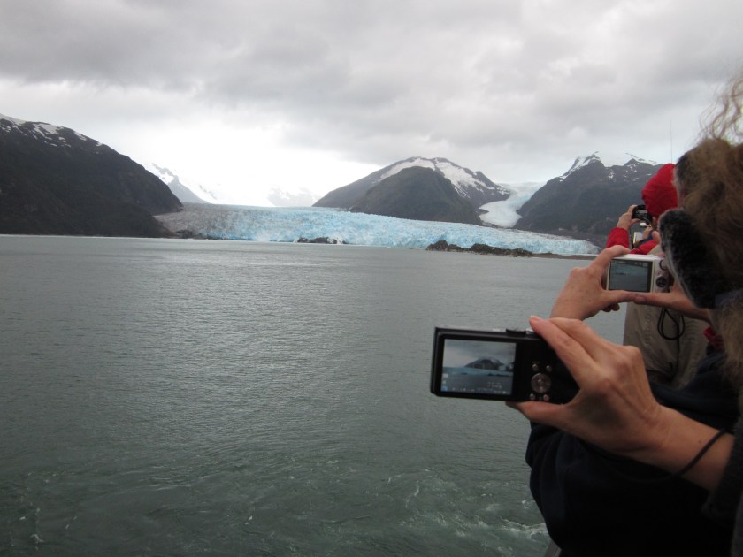
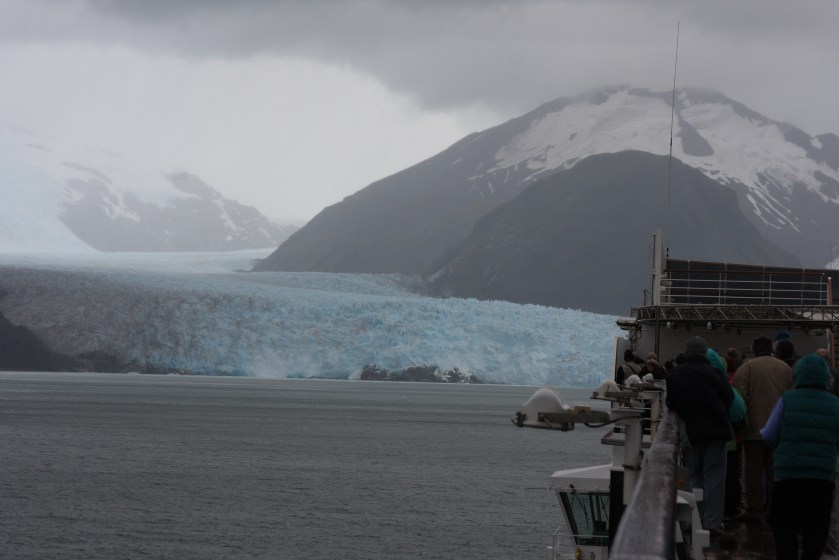
As it turned out, we did not go round Cape Horn itself. We went through the Beagle Channel, a strait in an archipelago on the southern tip of South America between Chile and Argentina. This channel separates the larger main island of Isla Grande de Tierra del Fuego from various smaller islands, its eastern area forms part of the border between Chile and Argentina whilst the western area is entirely within Chile. We saw some amazing sights such as glaciers and waterfalls and the views were just breathtaking, utterly indescribable, they were also changing by the minute. We then carried on to Punta Arenas, but we could not dock there because Arcadia was far too big. So those passengers booked on trips were ferried ashore using the ships tenders, which are also used as lifeboats if needed. When there is very little else to say we often to talk about the weather, but on this occasion it is totally appropriate as we had passed by a weather station a short while before. We learned that it is manned by two families and their nearest shops are a 50-mile boat trip away!!! The following day around 9:00am the sea state was very rough, meaning that the wave height was between 4 and 6 metres (13.1 to 19.7ft), with the swell reported as average and heavy. All in all it was a bit rough, but then Arcadia was designed to cope extremely well in such conditions and it did. The wind was still quite strong, around force 7, so some of the uppermost decks were closed off for safety reasons, but things soon calmed down. Later in the day we sailed up to and stopped for a while at the Amalia glacier – that really was a spectacular sight. Then it was on to Pio Decimo, also known as Pio X. For me personally this wasn’t as spectacular as the Amalia glacier, but it was still an amazing sight to see! It also rained, quite heavily at times, so by the time the ship started to turn away I was very wet! This meant that a compete change into dry clothes as well as careful checking and drying off of my camera equipment was needed! We were now on our way out to the Pacific Ocean, turning north for a while then winding in and out between various islands, before heading north again up to Chacabuco. I have sorted out three photos from all the ones I had taken of this spectacular area but I cannot decide which one to share. So here are all of them. I even managed to include a fun one which I like, a photo of others taking photos where you can see the view that they too are capturing!

Day 28. Friday February 1st. Latitude: 45,28,18S; Longitude: 72,49,42W.
The following day we anchored in the bay near to Chacabuco. The views were amazing, the hills all around, ice & snow on the mountains, with the clouds and sunshine changing the light all the time. Then there were rain showers and we could see them appearing from over the mountains! I didn’t go ashore though. Once all the passengers were back on board, the tenders were stowed away and after pulling up the anchor from its position at fifty metres down, we sailed away and were treated, around 7.00pm, to seeing a partial rainbow – it was a lovely sight. It meant that I could see the end of the rainbow as it disappeared into the water, but sadly the pot of gold is still at the bottom of that fjord…
Day 29. Saturday February 2nd. Latitude: 41,28,48S; Longitude: 72,56,12W.
The following morning I was awakened by the sound of a boat being lowered, ready for transporting people ashore to Puerto Montt. After my usual breakfast I did go ashore and have a good look around, taking a few photos of course! There was a small shopping area in what I discovered was the local bus station – this was all near the sea and there were some good views as the sun was out, the clouds were almost gone and it was beginning to warm up again. In the afternoon we were treated to a surprise air display from members of the Chilean Air Force – it was stunning! They used our cruise ship as a centre-point for their display, making really good use of the white smoke trails they created, ending with a heart shape with an arrow through it, finally creating a perfect 5-point star! The following morning the sun was shining, the outside temperature was 15C, or 59F if you prefer that scale. I discovered that I had caught the sun more than I realised yesterday, I should have worn my hat! My sunglasses would have been an idea too. I had my hair cut and some oil was put on my scalp as it really was very red! I knew it would settle down over the next day or two though. I had a busy day, what with the regular 10.00am ‘singles’ get-together, then I attended a coffee morning at the photo gallery, followed by lunch and various things in the afternoon, including the sorting out of photographs taken over the last few days. There was a good sunset, too.
Day 32. Tuesday February 5th. Latitude: 33,1,54S; Longitude: 71,37,36W.
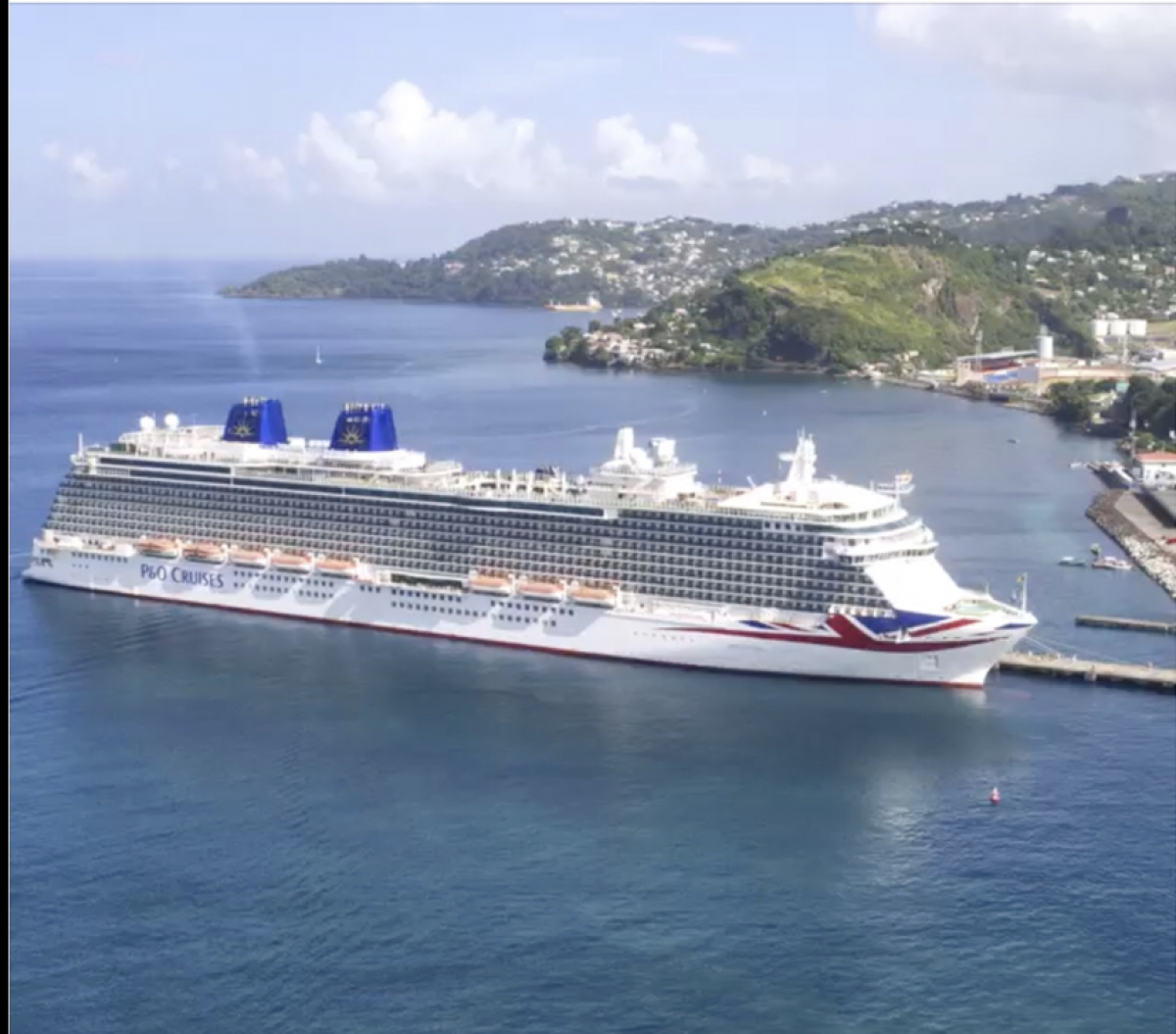
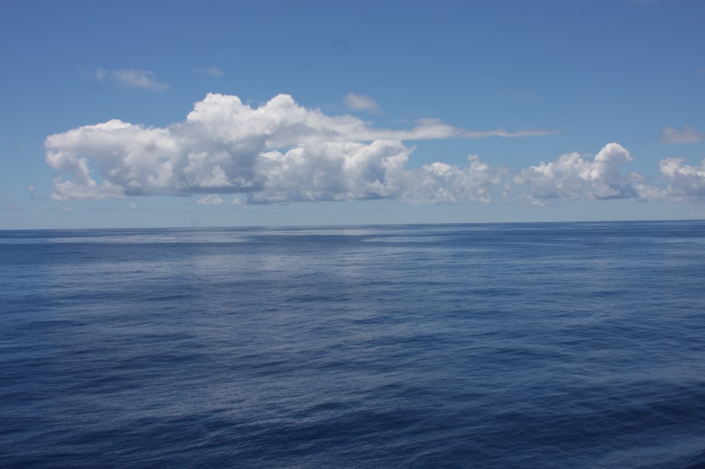
The driving distance between Puerto Montt and Valparaiso is around 587 miles (944 kilometres), but by sea it is slightly further. We proceeded at a steady pace on board Arcadia and so it was that a couple of days later we arrived in Valparaiso. This was the end of another cruise ‘sector’ and the beginning of the next, so 250 passengers left to go home and the same number of new passengers joined. We were required to take part in the standard ‘lifeboat exercise’ drill, where we go to our designated muster stations throughout the ship and this was set for 5.30pm, but those of us still away from the ship on shore excursions had already done this drill when we first went on board. After this visit, we were at sea for a full nine days. At 2.00am that morning the clocks went back one hour and more time adjustments were to come. We would pass by Easter Island and Pitcairn Island before reaching Papeete and this would give me time to simply relax and enjoy a few days at sea. I was beginning to understand why my maternal grandfather loved being at sea, it was constantly changing, sometimes calm, sometimes rough, with glorious sunrises and sunsets. There were some on board who wanted to be always doing things, whilst I was content to sit near the stern of the ship, watching and listening to the waves. But it was amazing how the ocean could be so calm at times…
We were now heading west, as you can see from the changing latitude and longitude details. There was a good sunset one night – not spectacular, but still lovely to watch. There was as much or as little to do on board as each individual wished, just what I needed. I had been neglecting my music though, so as I wrote my daily log I listened to some lovely music via my headphones – that way I could listen whilst walking around the ship, sitting outside or working inside in the ‘computer room’. I also had a few choices as to where to get refreshments, either free ones or purchased. The free coffee in the cafeteria was basic, made with hot water along with sugar sachets and the individual ‘long life’ milk cartons – basic Americano style. For latte or other speciality coffees there were several different places, there was a charge made for those, but I would treat myself! The clocks continued to go back in time, but it gave me extra sleep which I did take advantage of when it was needed. We were reminded about crossing the International Dateline a total of four times, so as a result 20th February and 12th March would not occur for us, but 10th March and 14th March would occur twice! Meanwhile the sea remained calm, the sky was blue, the sun was shining and I was enjoying my holiday. The following day we were due to sail by Easter Island, but there was a 25 knot wind which meant that with our relative speed we had winds of around 40 knots (around 45mph) over the deck – as a result we were warned to take good care when opening doors to the deck areas. These doors were quite heavy, so in very windy conditions needed some effort to open them. We continued westwards at a steady pace but for the next few days there was little to report on. Apart from relaxing out on deck in the sunshine though, there was always a great deal on board to keep us fed, fit and entertained. A wide range of eating places with varied foods, different deck sports, swimming pools, theatres, a night club, pubs, shops, a cinema and a gym to name but a few. There is so much that goes on. You might like to look at the P&O website Arcadia, Cruise Ship Exclusively for Adults | P&O Cruises for more detail! I also found the library. I guess my favourite place was The Crows Nest lounge, located just forward of deck 10. That is because it gave spectacular panoramic views and by day we could sit back, relax with perhaps a book as well as a coffee to just enjoy the view, whilst at night we had the chance to sip our favourite drink, at times accompanied by the sound of quiet piano music. But with this area located just forward of deck 10, I would have expected it to be called ‘Ten Forward’ – many of you will know why!
Day 39. Tuesday February 12th. Latitude: 25,3,18S; Longitude: 130,8,0W.
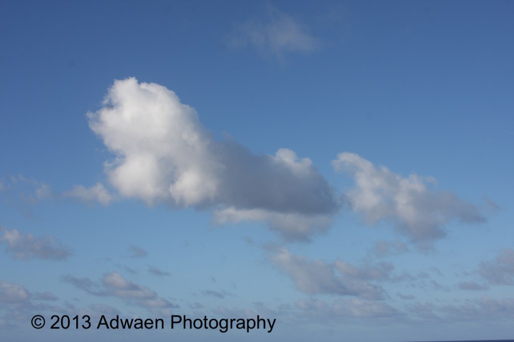
The Pitcairn Islands, officially the Pitcairn, Henderson, Ducie and Oeno Islands, are four volcanic islands which form the sole British Overseas Territory in the Pacific Ocean. These islands are scattered across several hundred kilometres of ocean and have a combined land area of about 18 square miles (47 square kilometres). Henderson Island accounts for 86% of the land area, but only Pitcairn Island is inhabited. The nearest islands are Mangareva (of French Polynesia) to the west and Easter Island to the east. Actually, Pitcairn is the least populous national jurisdiction in the world. The Pitcairn Islanders are a bi-racial ethnic group descended mostly from nine HMS Bounty mutineers and a handful of Tahitian captives, as is still apparent from the surnames of many of the islanders. As of January 2020, there were just 43 permanent inhabitants. So a few days later we were quite close to Pitcairn Island and circling whilst locals came aboard to sell some of their locally-made goods. After noon we headed towards our next port of call, Papeete, which I was advised is in fact pronounced Pah-pee-tay. We would arrive there in three days time. Our clocks kept on going back, we were now in the same time zone as San Francisco and this time change would occur again the next day. But as the old saying goes, times change… It was now that I managed to photograph the amazing cloud which looked to me like a howling dog. I thought it was so good that I used it later on my business cards. A couple of days later it was St Valentine’s Day. A dear lady friend said I was excused not getting her a card and a present – this time – as I was so far away, like 9,100 miles (14,645 kilometres)…
Day 42. Friday February 15th. Latitude: 17,32,18S; Longitude: 149,34,18W.
On our arrival into Papeete, the sky was a glorious blue – well, most of it, anyway! The sun was shining and it was a lovely day. At around 9.30am here it was 7.30pm UK time, so I did not see the asteroid that was passing by Earth. I was booked on a tour around Papeete that afternoon and as I have mentioned before, I do prefer to go on the ‘organised’ trips. If I had known my way around, it might have been a bit different. We had to be back on board ship by 5.30pm so we could sail away to our next port of call, Bora Bora.
Day 43.
Saturday February 16th. Latitude: 16,30,30S; Longitude 151,45,30W.
Sure enough, the following morning we were anchored in a lagoon at Vaitape, Bora Bora. At 8.00am the sun was shining, but dark clouds were visible. I immediately grabbed my camera! A member of the bridge crew had made an announcement regarding the possibility of rain showers later in the day and she was right about that! The view from the ship was lovely, what with Mount Otemanu rising up above us into the clouds, but with clear blue skies out above the lagoon. There was another cruise ship visiting Bora Bora, the Statendam from Rotterdam. Those going ashore had been reminded to make sure they boarded the correct tender and return to the right ship! This would have been highly unlikely, as each passenger had to show their cruise card to staff before leaving the ship, also boarding the tender for the return trip, and before returning on board. There had been quite heavy rain showers, but they had passed by quickly. It had been possible to see the rain bands approaching! The locals did have fun in their canoes though, trying to hold on to the tenders as they approached the ship, or use the wake from them to go faster.
International Dateline
Wednesday February 20th.
Because we crossed the International Dateline, this day did not exist for us.
Day 47. Thursday February 21st. Latitude: 18,8,5S; Longitude: 178,25,25E.
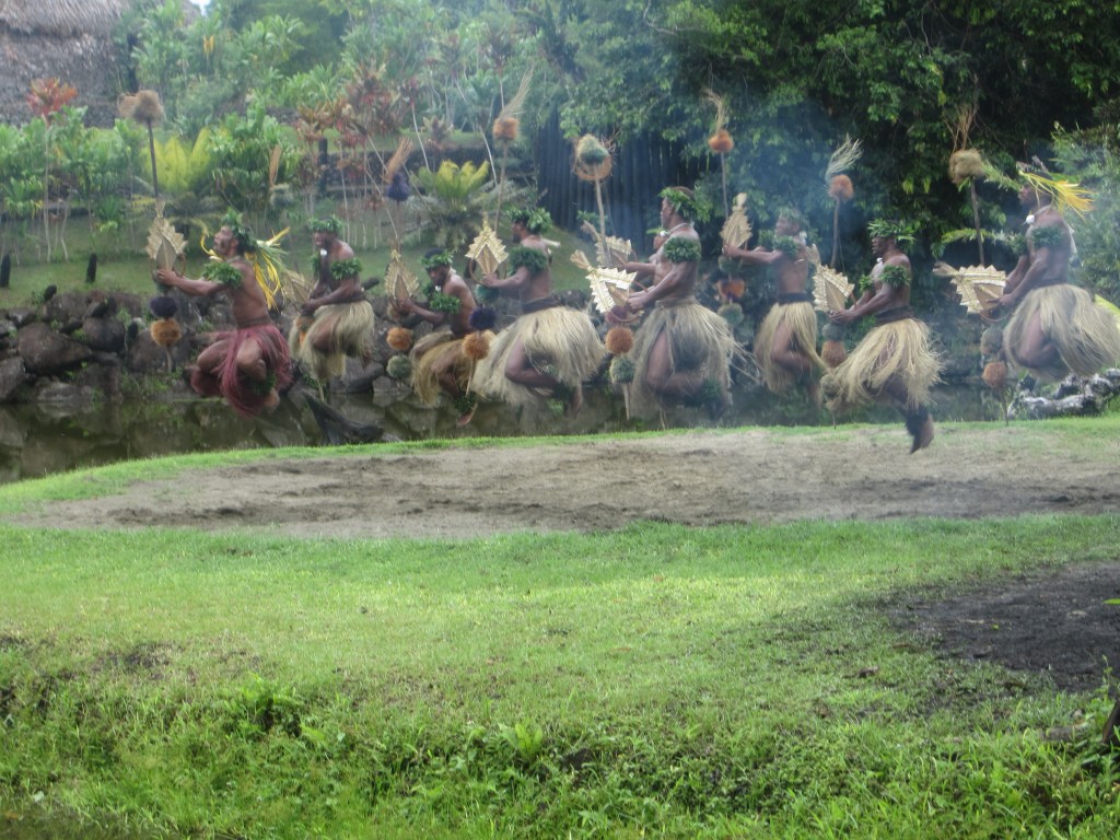
We arrived in Suva, Fiji. It was a very warm day but I thoroughly enjoyed it. I was on a tour which included men walking on hot stones, a mock tribal conflict as well as some traditional music & dance. The journey to where we saw all this was done via a local bus which had nothing like the features we had enjoyed on other coaches in other places as there were simply sliding windows, standard cushioned seating and no air-conditioning, but I really enjoyed it! The roads were a bit bumpy though. Sadly some people were complaining afterwards, but to me it was all part of being there! The following day we were steadily on course towards Noumea and it started out like being a cloudy day. But the skies cleared and it started to warm up, more than it already was! Most days that we were at sea, those of us who were on our own had the option to attend a ‘singles’ get-together, which I often did. However, there were other events on which we were clearly expected – or at least invited – to attend, so one day the singles event was cancelled! A few of us still met up at the usual place, but there was no sign of any free tea or coffee like there usually was. Not a problem, we still sat and chatted! A weekly ‘computer help’ group had been set up, so after lunch I met up with a few other passengers who had been designated as ‘mentors’ to help those with iPads and iPhones to use them better. The other mentors all felt that I knew the most on the subject, so I was doing one-to-one training with those who needed specific help, rather than just general assistance! It was kind of them to think so highly of me. I did my best.
Day 49.
Saturday February 23rd. Latitude: 22,15,54S; Longitude: 166,26,12E
The morning visit to Noumea was over quite quickly, I went on a tour which included a visit to a local aquarium, although it contained larger and more exotic fishes than I had ever seen before! I was able to take some photos, but using flash was not allowed. The time went very quickly, but we were able to see a bit of the main town as we drove back to Arcadia. We left at 1.00pm so that we could get to Brisbane on time. Because we were visiting Australia, we had to fill in forms for their Customs and Immigration checks and in other countries these checks had been done for us by staff from our ship, but this time we already had Immigration staff from Australia who had been brought on board. We had to present ourselves, along with our our entry & exit cards all filled in, to the immigration staff. We had designated times to attend these checks, starting from 9.00am, but we were also told we could attend early, from 7.30am, if we wished to do so. I decided to go early and discovered that a great many others had done the same! It didn’t take too long to be seen though. The staff checked all my passport details to ensure that I was who I said I was. My passport was then returned to the ship’s staff for safe-keeping. Job done.
Our next stop? Australia!
Click: Return to top of page or Index page
