
Ely (pronounced Ee-lee) is a cathedral city in the East Cambridgeshire district of Cambridgeshire, England, about fourteen miles (23 km) north-northeast of Cambridge and eighty miles (130 km) from London. Ely is built on a twenty—three square-mile (60 km2) Kimmeridge Clay island which, at eighty-five feet (26 m), is the highest land in the Fens. It was due to this topography that Ely was not waterlogged like the surrounding Fenland, and was an island separated from the mainland. Major rivers, including the Witham, Welland, Nene and Great Ouse feed into the Fens and, until draining commenced in the eighteenth century, formed freshwater marshes and meres within which peat was laid down. Once the Fens were drained, this peat created a rich and fertile soil ideal for farming. The Great Ouse river was a significant means of transport until the Fens were drained in the seventeenth century and Ely ceased to be an island. The river is now a popular boating spot, and has a large marina. Although now surrounded by land, the city is still recognised and remembered as “The Isle of Ely”. There are two Sites of Special Scientific Interest in the city, these being a former Kimmeridge Clay quarry, and one of the United Kingdom’s best remaining examples of medieval ‘ridge and furrow’ agriculture. The economy of the region is mainly agricultural and before the Fens were drained, eel fishing was an important activity, from which the settlement’s name may have been derived. Other important activities included wildfowling, peat extraction, and the harvesting of both osier (willow) and sedge (rush). The city had been the centre of local pottery production for more than 700 years, including pottery known as Babylon ware. A Roman road, Akeman Street, passes through the city with the southern end of this at Ermine Street near Wimpole and its northern end is at Brancaster. Little direct evidence of Roman occupation in Ely exists, although there are nearby Roman settlements such as those at Little Thetford and Stretham. A coach route, known to have existed in 1753 between Ely and Cambridge, was improved in 1769 as a toll road or turnpike. The present-day A10 closely follows this route whilst Ely railway station, built in 1845, is on the Fen line and is now a railway hub, with lines north to King’s Lynn, north-west to Peterborough, east to Norwich, south-east to Ipswich and south to Cambridge then London. King Henry II granted the first annual fair, Saint Etheldreda’s (or Saint Audrey’s) seven-day event, to the abbot and convent on 10 October 1189. The word “tawdry” originates from cheap lace sold at this fair and a weekly market has taken place in Ely market square since at least the thirteenth century. Markets are now held on Thursdays, Saturdays and Sundays, with a farmers’ market on the second and fourth Saturdays of each month. Present-day annual events include the Eel Festival in May, established in 2004, and a fireworks display in Ely Park, first staged in 1974. The city of Ely has been twinned with Denmark’s oldest town, Ribe, since 1956 and Ely City Football Club was formed in 1885.The nearby Roswell Pits are a palaeontologically significant Site of Special Scientific Interest, being just one mile (1.6 km) north-east of the city. The Jurassic Kimmeridge Clays were quarried in the nineteenth and twentieth centuries for the production of pottery and for maintenance of river embankments. Many specimens of extinct marine life have been found during quarrying. There is some scattered evidence of Late Mesolithic to Bronze Age activity in Ely such as Neolithic flint tools, a Bronze Age axe and spearhead. There is also some slightly denser Iron Age and Roman activity, with some evidence of at least seasonal occupation. For example, a possible farmstead, of the late Iron Age to early Roman period, was discovered at West Fen Road and some Roman pottery was found close to the east end of the cathedral on The Paddock. There was also a Roman settlement, including a tile kiln built over an earlier Iron Age settlement, in Little Thetford, three miles (5 km) to the south.

The origin and meaning of Ely’s name have always been regarded as obscure by place-name scholars, and these are still disputed. The earliest record of the name is in the Latin text of Bede’s ‘Ecclesiastical History of the English People’, where he wrote ‘Elge’. This is apparently not a Latin name, and subsequent Latin texts nearly all used the forms Elia, Eli, or Heli with inorganic H-. In Old English charters, and in the Anglo-Saxon Chronicle, the spelling is usually ‘Elig’. It has been said that the name Ely was derived from Old Northumbrian ‘ēlġē, meaning ‘district of eels’. The theory is that the name then developed a vowel to become ‘ēliġē’, and was afterwards re-interpreted to mean ‘Eel Island’ or Isle of Eels. The city’s origins lay in the foundation of an abbey in 673 AD, one mile (1.6 km) to the north of the village of Cratendune on the Isle of Ely, under the protection of Saint Etheldreda, daughter of King Anna. St Etheldreda (also known as Æthelthryth) was a queen, founder and abbess of Ely. She built a monastery in 673 AD, on the site of what is now Ely Cathedral. This first abbey was destroyed in 870 AD by Danish invaders and rededicated to Etheldreda in 970 AD by Ethelwold, Bishop of Winchester. The abbots of Ely then accumulated such wealth in the region that in the Domesday survey of 1086 it was the “second richest monastery in England”. The first Norman bishop, Simeon, started building the cathedral in 1083. The octagon was rebuilt by sacrist Alan of Walsingham between 1322 and 1328 after the collapse of the original nave crossing on 22 February 1322. Ely’s octagon is now considered “one of the wonders of the medieval world”. Building continued until the dissolution of the abbey in 1539 during the Reformation. The cathedral was then sympathetically restored between 1845 and 1870. As the seat of a diocese, Ely has long been considered a city and in 1974, city status was granted by royal charter.

Cherry Hill is the site of Ely Castle which is of Norman construction and is a United Kingdom scheduled monument. Of similar construction to Cambridge Castle, the 250-foot (76 m) diameter, 40 feet (12 m) high citadel-type ‘motte and bailey’ and is thought to be a royal defence built by William the Conqueror following submission of the Isle from rebels such as the Earl Morcar and Hereward the Wake. This would date the first building of the castle to c. 1070. On 9 April 1224, although Ely had been a trading centre prior to this, King Henry III of England granted a market to the Bishop of Ely using “letters close”, a type of obsolete legal document once used by the Pope, the British monarchy and by certain officers of government, which is a sealed letter granting a right, monopoly, title, or status to an individual or to some entity such as a corporation. Present weekly market days are Thursday and Saturday and seasonal markets are held monthly on Sundays and Bank Holiday Mondays from Easter to November. Following the accession of Mary I of England to the throne in 1553, the papacy made its first effective efforts to enforce the Pope Paul III-initiated Catholic reforms in England. During this time, which became known as the Marian Persecutions, two men from Wisbech were accused of not believing that the body and blood of Christ were present in the bread and wine of the sacrament of mass. This was viewed as Christian heresy and they were condemned and were burnt at the stake. The cathedral itself was dedicated to St Peter at this time and a windmill is shown on Mount Hill where the post-conquest Ely Castle motte and bailey once stood. In the eighteenth century trees were planted on Mount Hill which was named Cherry Hill since at least since 1821. There was a form of early workhouse in 1687, perhaps at St Mary’s and then a purpose-built workhouse was erected in 1725 for thirty-five inmates on what is now St Mary’s Court. Four other workhouses existed, including Holy Trinity on Fore Hill for eighty inmates (1738–1956) and the Ely Union workhouse, built in 1837, which housed up to three hundred inmates. The latter became Tower Hospital in 1948 and is now a residential building, Tower Court. Two other former workhouses were the Haven Quayside for unmarried mothers and another on the site of what is now the Hereward Hall in Silver Street. Over the years various diarists have written about Ely, for example Daniel Defoe, when writing in the Eastern Counties section of ‘A tour thro’ the whole island of Great Britain’ (1722), wrote “to Ely, whose cathedral, standing in a level flat country, is seen far and wide … that some of it is so antient, totters so much with every gust of wind, looks so like a decay, and seems so near it, that when ever it does fall, all that ’tis likely will be thought strange in it, will be, that it did not fall a hundred years sooner”. The Ely and Littleport riots occurred between 22 and 24 May 1816. At the Special Commission assizes, held at Ely between 17 and 22 June 1816, twenty-four rioters were condemned. Nineteen had their sentences variously commuted from penal transportation for life to twelve-months imprisonment; the remaining five were executed on 28 June 1816. I have also seen it noted that an outbreak of cholera isolated Ely in 1832.
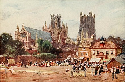
The above shows the north-east aspect of [Ely Cathedral in the background with the Almonry which is now a restaurant and art gallery. In front of that is the 1847 corn exchange building, now demolished, to the right of the picture. Ely Cathedral was “the first great cathedral to be thoroughly restored”. Work commenced in 1845 and was completed nearly thirty years later; most of the work was “sympathetically” carried out by the architect George Gilbert Scott. The only pavement labyrinth to be found in an English cathedral was installed below the west tower in 1870. For over 800 years the cathedral and its associated buildings, built on an elevation sixty-eight feet (21 m) above the nearby fens, have visually influenced the city and its surrounding area. The abbey at Ely was one of many which were re-founded in the Benedictine reforms of King Edgar the Peaceful (943–975). The “special and peculiarly ancient” honour and freedoms given to Ely by charter at that time may have been intended to award only fiscal privilege, but have been interpreted to confer on subsequent bishops the authority and power of a ruler. These rights were reconfirmed in charters granted by King Edward the Confessor and in King William the Conqueror’s confirmation of the old English liberty at Kenford. The Isle of Ely was mentioned in some statutes as a county palatine; this provided an explanation of the bishop’s royal privileges and judicial authority, which would normally belong to the sovereign; but some legal authorities did not completely endorse the form of words. These bishop’s rights were not fully extinguished until 1837.

As the seat of a diocese, Ely has long been considered a city, holding the status by ancient prescriptive right. When Ely was given a Local Board of Health by Queen Victoria in 1850, the order creating the board said it was to cover the “city of Ely”. The local board which governed the city from 1850 to 1894 called itself “City of Ely Local Board”, and the urban district council which replaced it and governed the city from 1894 to 1974 similarly called itself “City of Ely Urban District Council”. Ely’s city status was not explicitly confirmed, however, until 1 April 1974 when Queen Elizabeth II granted letters patent, to its civil parish. Ely’s population of 20,256 (as recorded in 2011) classifies it as one of the smallest cities in England, although the population has increased noticeably since 1991 when it was recorded at 11,291. Its urban area brings Ely into the top ten of smallest sized cities (1.84 square miles, 4.77 km2), but by city council area it is much larger in coverage (22.86 square miles, 59.21 km2) than many others.
There are three tiers of local government covering Ely, at parish (city), district, and county level, these being the City of Ely Council, East Cambridgeshire District Council and [Cambridgeshire County Council. In terms of its administrative history, the city was governed by a local board from 1850 until 1894, when it became the City of Ely Urban District Council, which then operated from 1894 to 1974. The Isle of Ely County Council governed the Isle of Ely administrative county that surrounding and included the city from 1889 to 1965. In 1965 there was a reform of local government that merged the county council with that of Cambridgeshire to form the Cambridgeshire and Isle of Ely County Council. In 1974 as part of a national reform of local government, the Cambridgeshire and Isle of Ely County Council merged with the Huntingdon and Peterborough County Council to form the [Cambridgeshire County Council and it was sadly around this time that Whittlesey, where I grew up, ceased to be part of the Isle of Ely. The City of Ely Urban District Council became the City of Ely Council, a parish council which covers the same area but with fewer powers, and the East Cambridgeshire District Council which covers a wider area.

The west of Cambridgeshire is made up of limestones from the Jurassic period, whilst the east Cambridgeshire area consists of Cretaceous, upper Mesozoic chalks known locally as clunch’. In between these two major formations, the high ground forming the Isle of Ely is from a lower division Cretaceous system known as Lower Greensand which is capped by Boulder Clay and all local settlements, such as Stretham and Littleport, are on similar islands. These islands rise above the surrounding flat land which forms the largest plain of Britain from the Jurassic system of partly consolidated clays or muds. Kimmeridge Clay beds dipping gently west underly the Lower Greensand of the area exposed, for example, about one mile (2 km) south of Ely in the Roswell Pits. The Lower Greensand is partly capped by glacial deposits forming the highest point in East Cambridgeshire, rising to 85 feet (26 m) above sea level in Ely. The low-lying fens surrounding the island of Ely were formed, prior to the seventeenth century, by alternate fresh-water and sea-water incursions. Major rivers in the region drain an area of some 6,000 square miles (16,000 km2), five times larger than the fens, into the basin that forms the fens. Peat formed in the fresh-water swamps and meres, whilst silts were deposited by the slow-moving sea-water. The Earl of Bedford, supported by Parliament, financed the draining of the fens during the seventeenth century, led by the Dutch engineer Cornelius Vermuyden and the fens continue to be drained to this day. As an island surrounded by marshes and meres, the fishing of eels was important as both a food and an income for the abbot and his nearby tenants. Prior to the extensive and largely successful drainage of the fens during the seventeenth century, Ely was a trade centre for goods made out of willow, reeds and rushes and wild fowling was a major local activity. Peat in the form of “turf” was used as a fuel and in the form of “moor” as a building material. Ampthill Clay was dug from the local area for the maintenance of river banks and Kimmeridge Clay at Roswell Pits for the making of pottery wares. In general, from a geological perspective, “The district is almost entirely agricultural and has always been so. The only mineral worked at the present time is gravel for aggregate, although chalk, brick clay (Ampthill and Kimmeridge clays), phosphate (from Woburn Sands, Gault and Cambridge Greensand), sand and gravel, and peat have been worked on a small scale in the past”. Phosphate nodules, referred to locally as coprolites were dug in the area surrounding Ely between 1850 and 1890 for use as an [agricultural fertiliser and this industry provided significant employment for the local labour force. One of the largest sugar beet factories in England was opened two miles (3 km) from the centre of Ely, in 1925. The factory closed in 1981, although sugar beet is still farmed locally. Pottery was made in Ely from the twelfth century until 1860 and records show around eighty people who classed their trade as potters. “Babylon ware” is the name given to pottery made in one area of Ely. This ware is thought to be so named because there were potters in an area cut off from the centre by the re-routing of the Great Ouse river around 1200, by the seventeenth century this area had become known as Babylon. Although the reason for the name is unclear, by 1850 it was in official use on maps. The building of the Ely to King’s Lynn railway in 1847 cut the area off even further, and the inhabitants could only cross to Ely by boat.
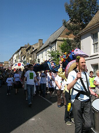
Annual fairs have been held in Ely since the twelfth century. Apart from Saint Audrey’s (Etheldreda) seven-day fair, held either side of 23 June, which was first granted officially by King Henry I to the abbot and convent on 10 October 1189, two other fairs, the 15‑day festival of St Lambert, first granted in 1312 and the 22‑day fair beginning on the Vigil of the Ascension, first granted in 1318. Have been held. The festival of St Lambert had stopped by the eighteenth century. St Etheldreda’s and the Vigil of the Ascension markets still continue, although the number of days have been considerably reduced and the dates have changed. Present-day annual events in Ely include Aquafest, which has been staged at the riverside by the Rotary Club on the first Sunday of July since 1978. Other events include the Eel Day carnival procession and the annual fireworks display in Ely Park, first staged in 1974. The Ely Folk Festival has been held in the city since 1985 and the Ely Horticultural Society have been staging their Great Autumn Show since 1927. Interestingly, the children’s book ‘Tom’s Midnight Garden’ by Philippa Pearce is partly set in Ely and includes a scene in Ely Cathedral and scenes inspired by the author’s father’s own childhood experiences of skating along the frozen river from Cambridge to Ely in the frost of 1894–95. Also the first series of Jim Kelly’s crime novels, featuring journalist Philip Dryden, is largely set in the author’s home town of Ely and in the Fens. Graham Swift’s 1983 novel ‘Waterland’ takes place, and recounts several historical events, in and around the town of Ely. The Tales of the Unexpected episode “The Flypaper” was filmed in Ely and the album cover for Pink Floyd’s ‘The Division Bell’ was created by Storm Thorgerson with Ely as the background between two massive sculptures that he had erected outside the city.
This week… A quote from an army officer:
Him? “I wouldn’t trust him with a pea shooter!”
Click: Return to top of page or Index page
